What can a map tell us?
 Over the past two weeks I’ve been working with our 3rd grade teachers on a social studies project to introduce the students to some mapping skills. Of course the USSR no longer exists, yet many atlases in schools and even school encyclopedia talk about the USSR as though you should be able to find it on a map. The left overs of social studies curriculum reviews that seem to always get pushed to be the last curriculum to be updated at schools. Funny how we want our students to be “global citizens”, “globally aware”, and communicate globally, yet our curriculum in this area seems to fall behind, math, reading, writing, and science. Maybe it’s just me and the 3 past schools I’ve worked at and where they are in the curriculum review cycle….or is it the pressure of standardize testings taking it toll. Most standardize tests do not have a social studies component and we all know that what doesn’t get tested doesn’t get………anyway. 😉
Over the last three weeks we’ve been looking at maps…and just for a second stop and think about the maps these kids are going to need to know how to navigate in their future. You’re still going to need an atlas when trying to find your way across Thailand, but a GPS is better for most parts of America. Then there is Google Earth and it’s ever constantly updated data (we looked at the typhoon off Japan today). Google Maps with its street view and pin point addresses, and iPhones and BlackBerries that let you find places on the go.
Oh how the mapping world has changed yet the skills of reading a map have remained the same. On that note here are the first three lessons I’ve been co-teaching with 3rd grade teachers around comparing maps and answering the question “What can a map tell us?”
Lesson 1: Google Earth Exploration
Whenever you introduce a new program/tool to students on the computer I find it well worth the time to give them 10-15 minutes to just play with the program. Of course we’re not allowed to “play” in the classroom as I tell the kids…so let’s call it explore in case the principal walks in. This always gets a couple of laughs and we spend the rest of the time with this little inside joke about “exploring” the program (picture 3rd grader making the quotes in the air as they say explore….so cute!).
After this explore time we come back together and the students report on what they learned. Most of the time they have covered and shared all the basic movements of how to work Google Earth. Zoom, rotate, search, orient. Done…and probably faster than I could have taught the skills individually to the class.
Next I set up a “Start Position” so that when I say “Please return your Earth to start position” students know what I mean. For us that’s zoomed out to see the whole world on your screen and oriented so the N for north is facing up. From there we can continue to the next part of any lesson over the next couple of days.
 Lesson 2: Continents and Oceans
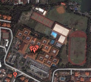
Next lesson we look at a map of the world (great free maps here) and we start the lesson by talking about how important a compass is to a map (building on the N facing up in Google Earth) we draw a compass on our map and write our names in the North/East corner (only N/S/E/W directions wil be given from this point on).
Next we compare the map sitting in front of us to Google Earth (Google Earth not required) that we “explored” last session. Students come up with the following similarities and differences:
- Both have land and water
- Google Earth allows you to search for places
- Google Earth allows you to zoom in
- “I can’t find my house on this map”
- Google Earth is more colorful
In all three classes I’ve done this in so far the first difference that students point out is the ability to search…that is a whole other blog post!
After we do this short activity we use a SmartBoard Notebook file to find and name the different continents and oceans. As students uncover or move the continents on the SmartBoard we color the continents in different colors on our maps and label the oceans. (Writing this at home, tomorrow will upload and share Notebook file)
Lesson 3: Transferring information
One of the outcomes is to get students to understand the concentric nature of maps. Continents to Countries to States/Providences to Cities. We’ve now covered the continents in the previous lessons and move to countries. Seeing that Asia is where our students have had the most experience we start there. We open up Google Earth turn on the boarders and labels layer and match the countries in Asia with the country outlines on our Asia map. We then label the countries and zoom in on Thailand to mark major cities. (I haven’t taught this lesson yet…..but this is what we hope happens.)
That’s where we’re at so far, it’s a short unit of study but our hope is by the end of it students will create their own Google Earth tour. If we get there….I’ll be sure to post the results here!



RT @jutecht: Just Blogged: What can a map tell us? http://bit.ly/12Mp3X
This is a great lesson plan. Thanks
This is good stuff–thanks for talking about maps. They do not get enough attention. In addition to what you’ve provided, you have to see http://www.stratalogica.com. I just got a brochure in the mail on this. It’s ggogle earth workig with Nystrom maps and globes…a real innovation.
I love these lesson plan ideas – I want to try them next week with my new class. I think getting kids to link technology which is in their blood (google earth) to old fashioned maps is a fantastic way to get them hooked. Thanks for sharing! And I hope you post after you teach that third lesson.
Our school district has stopped buying map for the classroom because of the fact they become outdated so quickly. I use Google Map all of the time when teaching and reviewing map skills. I also use the internet to gather up to date maps and use them along with my ACTIVboard to compare and contrast the different maps.
[…] World Landform Tour via Google Earth Saturday, September 26, 2009 By Jeff Utecht Hello there! If you are new here, you might want to subscribe to the RSS feed for updates on this topic.World Landform Tour via Google EarthOver the past couple of weeks I’ve been working closely with a couple of our 3rd grade teacher looking at their mapping unit and using Google Earth. I talked about the lessons I was helping with a couple blog posts ago. […]
RT @jutecht What can a map tell us? | The Thinking Stick http://bit.ly/77010t Another approach using both print and online map resources.